
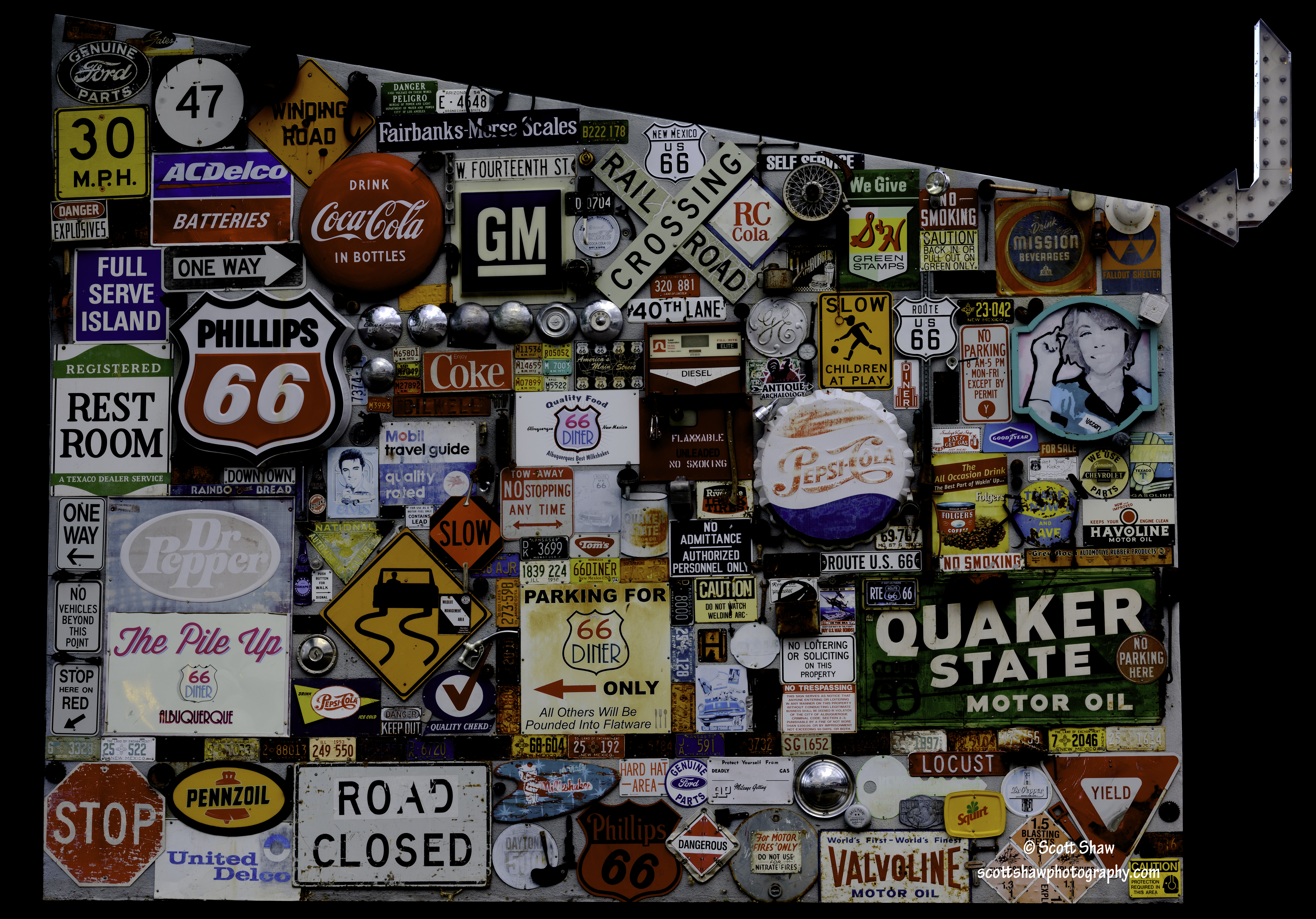
Albuquerque Sign Building (click to enlarge)
While driving down Albuquerque’s Central Avenue, I stopped to eat at the 66 Diner. At the north end of the parking lot sits a building with one wall covered in old highway signs. Much like my image of MH-53J #68-10367 there was a lot of background clutter around the building.
I decided to just cut out the wall itself along with the neon arrow in the upper right corner. I made the background black to match the theme of this website and focus attention onto the signs themselves.
Sign Building: N35 04 55.20 W106 37 49.85

MH-53J #68-10367 (click to enlarge)
Meet MH-53J #68-10367. The aircraft is located just inside the gate to Cannon Air Force Base. #68-0367 is a famous aircraft within the Air Force Special Operations Command. Here is part of the text on the plaque in front of the aircraft:
On 17 January 1991 this aircraft was part of a flight of aircraft that kicked-off Operation DESERT STORM. It penetrated Iraqi airspace as a member of Task Force Normandy, leading U.S. Army AH-64 Apache helicopters to strike enemy radar installations and clearing the way for the follow-on campaign.
Here is a link to a pretty detailed history of the MH-53 Pave Low helicopter. The front cover of this paper shows a sister ship of #68-10367 in all of its gritty glory. You can read about Task Force Normandy starting on Page 305 of that paper in the section entitled Eve of Combat.
I actually took this image around 0200 (2:00 AM for my civilian followers). I had taken a few images of the aircraft during the day, but there is just too much background clutter. At that point I decided to take a night image. At night most of the background is black with a few stray lights. I cut out the distractions and made the background a uniform black. I used a focal length of 24mm and positioned my tripod just beside the in-flight refueling probe (that grayish bulbous thing in the left front foreground).
MH-53J #68-10367: N34 24 03.34 W103 19 05.16
Apparently the aircraft has not been in this spot very long as it does not appear on GoogleEarth.

New Mexico Road Trip Locations (click to enlarge)
Here is a map of the photography locations I visited during a recent business trip to New Mexico. This is a screen capture from the Map Module in Adobe Lightroom. The Map Module makes it easy to visualize where you have been and select images from a certain location.
Using the numbers in the boxes as references, here are the locations I visited. Future posts will cover each of these locations in some detail. Starting in Albuquerque and proceeding clockwise:
37 – On this trip I focused on the old motel signs along Route 66 in Albuquerque.
75 – Old Town Sante Fe
22 – Pecos National Historic Park
67 – Fort Union National Monument
34 – Cadillac Ranch
6 – Cannon Air Force Base
11 – Taiban
3 and 3 – Billy the Kid Grave Site and Museum
46 – Carlsbad Caverns (not shown)
26 – Salinas Pueblo Missions National Monument – Gran Quivira
5 – A random ranch on the way to Gran Quivira
7 – Mountainair
21 – Salinas Pueblo Missions National Monument – Quarai
I visited these locations over two weekends, and lots of miles on my rental car!
